UrtheCast Release First HD Video From the ISS
UrtheCast Releases First Full-Color HD Videos from the International Space Station, SpaceRef Business
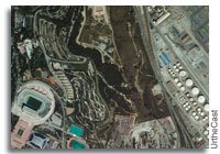
“Today UrtheCast released their first full-color HD video of Earth filmed in roughly 1 meter resolution of London, Boston and Barcelona.”
![]() Marc’s note: It’s quite something to watch cars drive around from LEO.
Marc’s note: It’s quite something to watch cars drive around from LEO.


I wonder how they intend to use this? If there were good live coverage in major highways you could get a real time view of traffic flow and blockages. For instance right now there are a lot of people stuck out on the highway south east of Houston. you might be able to see where the blockages were located and reroute them. But we’re talking a lot of imagery from a lot of places, all simulcast. That might be a tough nut to crunch.
Anyone can order data from Urthecast, they are a data provider.
Though for monitoring regional highway traffic in real-time, I’d suggest a high altitude UAV or blimp.
That’s been done for years using live video feed and traffic sensors.
SpaceTech is correct; real-time traffic information already exists from much simpler sources: traffic cameras. Major cities have traffic cameras all over the roads, and that video coupled with data from smart phone GPS sensors already feeds into traffic systems.
I can see this being useful for emergency situations in which normal means of monitoring aren’t available, such as refugees fleeing $DISASTER. Of course, there would have to be a suitable ISS pass.
ISS travels at an estimated 17,500 mph. How are they able to capture moving traffic in what appears to be an otherwise stationary image?
Crew members on ISS have to use panning techniques (or something like ESA’s Night Pod) in order to get a relatively decent still image without motion blur, and even then their window of opportunity for any given target is pretty short.
For a 90 minute orbit, a 1 min video will subtend just 4°. This is apparent in the changing angle of any tall structure in the videos (the London Eye is particularly obvious.)
While the geometry may be correct, I’m not sure that’s what we’re seeing. Although it only subtends 4°, in one minute the ISS travels a ground distance of roughly 270 miles (if my math is right – I’m happy to be corrected here).
Consider the nadir camera on the HDEV payload. It has a fairly large field of view and the Earth moves by at a pretty good clip. Zoom in farther and the apparent motion will be even greater. Yet, the motion in these videos is slow enough that there is time to watch cars travel down the road in real-time.
Considering what we know about Earth photography from ISS, I’m having a hard time understanding what’s going on here.
No, you’re being too polite, my geometry was moronic. They’re not filming the centre of the Earth. Thank you, you are quite right.
Let’s see if I can make up for it…
If the ISS tracks around 450km per minute and is, coincidentally, around 450km up (bit less, IIRC), then the camera’s tracking angle is around 50° per minute (on a flat plane, trivially more because it’s in orbit), so about 30° in the London video. Which makes more sense with what we’re seeing.
(I was so stupid. The London Eye appears to tilt through a hell of a lot more than 4°. This sounds a lot closer, over 15° east to not quite 15° west.)
There may be some electronic correction of the distortion of parallax — keeping the square square — but because the ISS is around 500km away at the beginning and end of the video, and the area being videoed is quite small (1x2km), the amount of parallax is going to be tiny, around a tenth of a percent in the London video (1-2m). It’s just counter-intuitive as hell, of course, because we’re so zoomed in our apparent viewpoint is only a few miles up where parallax would be substantial (10-20%, over 200m difference at the corners).
(There’ll also be a slight change in scale, but even that’s less than 5% in the London video, ie, about 25m per side. It may be electronically corrected, I can’t tell.)
This is just the “civilian” side – imagine the MILSPEC stuff. The commercialization of space will continue despite the whining and moaning inside the 495.
The beatings will continue.
GeoEye can get to about .4 meters per pixel. The US military was trying to prevent them from releasing any imagery better than .5 meters per pixel on sensitive US locations, but eventually gave up on that.
Estimates vary, but likely the best the military can do is about .2 meters per pixel, given that the mirrors on spy telescopes are known to be less than 3 meters across. Any better than that would require much larger mirrors.
Some corrections. The angular resolution of a telescope is determined by Rayleigh criterion, and has nothing to do with the pixel size as long as your highest resolution is properly sampled. For a 3 meter class telescope, the theoretical resolution is roughly 1.7E-7. If the satellite orbits at 160 km above ground (spy satellite usually fly at low orbit to achieve best imaging quality), the resolution translates to 1.7E-7*160,000=0.026 m rather than 0.2 m.
Without adaptive mirrors, that 0.026m resolution would never be achievable due to atmospheric turbulence, and the problem with adaptive optics is needing a reference from which to measure aberrations. That reference would be lacking. The Rayleigh criteria also assumes that the system in question is diffraction limited, which may not be applicable, certainly not in the case where atmospheric turbulence is a factor, as mentioned earlier.
It turns out that atmospheric turbulence does play a part in limiting resolution. See
http://www.satobs.org/seesa…
Yup. That’s why the majority of optical observatories coming on line have and will have adaptive optics and laser guide stars.
You’re right, that is the best theoretically possible resolution for a 3 meter mirror at that altitude, though mirror sizes are probably smaller, and there are a lot of other factors involved. Atmospheric distortion and short exposure times (necessary to avoid blurring from the motion of the satellite) prevent achieving such resolutions on a regular basis. 3 meters is an upper size limit for a primary mirror, based on the known size of satellite buses. I’d expect that they have a range of mirror sizes, from 2.1 meters across (the size of Hubble’s mirror) up to 3 meters. My WAG is that 2.5 to 2.8 meters would be more common.
It should also be noted that pixel size absolutely impacts image resolution, which is the resolution that really matters. Having a spot size smaller than a pixel limits the resolution to that pixel dimension unless you do some fancy math and image processing with multiple exposures to achieve sub-pixel resolution.
Sort of a random thought, but it occurs that the UrtheCast system collects a lot of photons from any given spot on the ground during a video pass and I wonder if you could use something like RegiStax to achieve low-light capability. Might be interesting to get some night-time videos and try it out.