Snowstorm Update
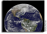 Monster Snow Storm As Seen From Space
“The monster winter storm that brought icing to the U.S. southeast moved northward along the Eastern Seaboard and brought snow, sleet and rain from the Mid-Atlantic to New England on February 13. A new image from NOAA’s GOES satellite showed clouds associated with the massive winter storm stretch from the U.S. southeast to the northeast.”
@NASA_Marshall Marshall will resume operations & reopen Friday, Feb 14. Only Gates 9, 7, 1 will be open for early commute. Watch for ice; travel carefully!
OPM Status
Federal agencies in the Washington, DC, area are OPEN under 2 hours DELAYED ARRIVAL and employees have the OPTION FOR UNSCHEDULED LEAVE OR UNSCHEDULED TELEWORK. Employees should plan to arrive for work no more than 2 hours later than they would be expected to arrive.
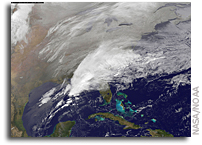 Large Southeastern Snowstorm As Seen From Orbit
“Clouds associated with the major winter storm that is bringing wintry precipitation and chilly temperatures to the U.S. south is the focus in an image from NOAA’s GOES-East satellite today, February 12 at 1310 UTC/ 8:10 EST. Rain, freezing rain, sleet and snow are part of the large front that stretches from eastern Texas to the Carolinas in the Geostationary Operational Environmental satellite or GOES image.”
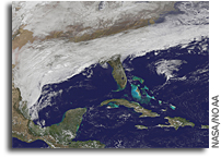 Satellite Shows Major Winter Storm Hitting the U.S. South
“Clouds associated with the major winter storm that is bringing wintry precipitation and chilly temperatures to the U.S. south is the focus in an image from NOAA’s GOES-East satellite today, February 11 at 1815 UTC/1:15 p.m. EST. NOAA’s National Weather Service has been issuing watches and warnings throughout the south that extend along Mid-Atlantic east coast.”